
For centuries a thin traders’ track linked Kashmir with Delhi through Rajouri and Lahore. Then about 400 years ago Jehangir, the Mughal Emperor (1569 to 1627) artist, builder and conqueror widened the pencil line so that his elephants, camels, horses, dogs, pet leopards, palanquins and about 30,000 retainers could move safely on his frequent summer visits to Kashmir. Aurangzeb the last of the Great Moghuls got to Kashmir only once in 1665. It was during this visit that 15 elephants and four ladies perished in an accident below the Pir Panjal Pass possibly above today’s Poshiana village(Francois Bernier: Pg. 409, Travels in the Moghal Empire .Publ- 1670). That was the last of the grand caravans.


The route continued being used by traders and Gujars – high altitude shepherds- on their twice a year migrations. From mid 19th C till the early 20th C several British explorers went this way but eventually the easier Rawalpindi- Uri route to Kashmir drew away all travelers leaving only the Gujars to walk this trail, which was gentle on the Kashmir side and tough from Rajouri.

In the early 50s Sheikh Abdullah planned to connect Srinagar with Rajouri with a motorable road along the old Mughal Road. Lack of Central support and insurgency scuttled that dream for many decades. In 2005 construction started, but it was Omar Abdullah, the present Chief Minister, who pushed the doddering project towards completion. There were now only 84 kms of road to be built. The Centre gave Rs. 300 crores and the J & K PWD built the link, from Shopiyan in Kashmir to Bafliaz in Punch, in three years.

About 25 kms between Pir Panjal Pass (Pir Ki Gali) and Dogrian village on the Rajouri side are metalled in patches, but hundreds of taxis and a few buses do the trip daily till winter snows stop traffic.

'But Shopiyan in Autumn is bustling with apple related energy and commerce round the clock'

The old Mughal Road had Serais (large inns) and forts every 20 kms or so. Some of them are by the road and others can be seen from the road. Jehangir and Nur Jehan had done the most to dot the entire length from Delhi to Srinagar with grand large Serais which reduced in size as the mountains started.
Before Shopiyan the Rambiara flows quietly in autumn


From Srinagar, which has many structures from the Mughal era, to Shopiyan, the road is narrow and crowded. Shopiyan is one of the Valley’s largest centers for apples. Trucks go straight from here to all the large cities in India. After Shopiyan the wide new Mughal Road makes driving a pleasure. The road passes from extensive views of the Rambiara river crowned by Sunset and Tata Kuti peaks of the Pir Panjal Range to extensive forests of tall deodars (firs) of the Herpora Wild Life Sanctuary.

At Dubjan,

a delightful large meadow surrounded by a few remaining pines and firs (most have been axed), the road crosses the Rambiara as it darts out of the restricting mountains to sprawl in the valley. Here is an army post and a store for bridge things. Nearby and below the road is a tastefully made wooden perch to view the pines and firs crowded valley and the higher slopes of silver barked birches leading to a snow ridge of the Pir Panjal Range. About 2 kms away, in a delightful meadow on a large mound above the confluence of Rupri stream with Panyar Yanga Nar are the ruins of 17th C Sokh Serai well past any hope of preservation. The snow ridge conceals a bevy of lakes on its east and western sides. Nandan sar, Chandan sar, Bhag sar and Katori sar etc. These were very popular trek destinations till the eighties, but now even though there seems to be no human movement the army does not allow any ‘adventurism’ here, as they fear that insurgents are still lurking about.


About 5 kms after Dubjan- a popular picnic spot for Kashmiris- the tree line is cleared and the road makes a long and ugly gash in a long and lovely alp till the Pir Panjal Pass (Pir ki Gali as it is better known today and PKG in the accompanying map) 16 kms away. The bridge over Panyar Yanga Nar is still being made so a dusty diversion is taken. Around this point is a sign inviting to admire the Aliabad Serai about 250 mtrs below set in a vast meadow called Pir Marg aglow with yellow anemones in October and blue iris (mazar posh in Kasmiri), yellow potentila and white saxifrage in July.
This


=

'The road is so comfortable that migrating Gujars in autumn take the tarred road leaving their old traditonal paths lower down- ' With Mount Harmukh - at 16,870' is Kashmir Valley's highest peak- glistening at the back>


The Aliabad Serai

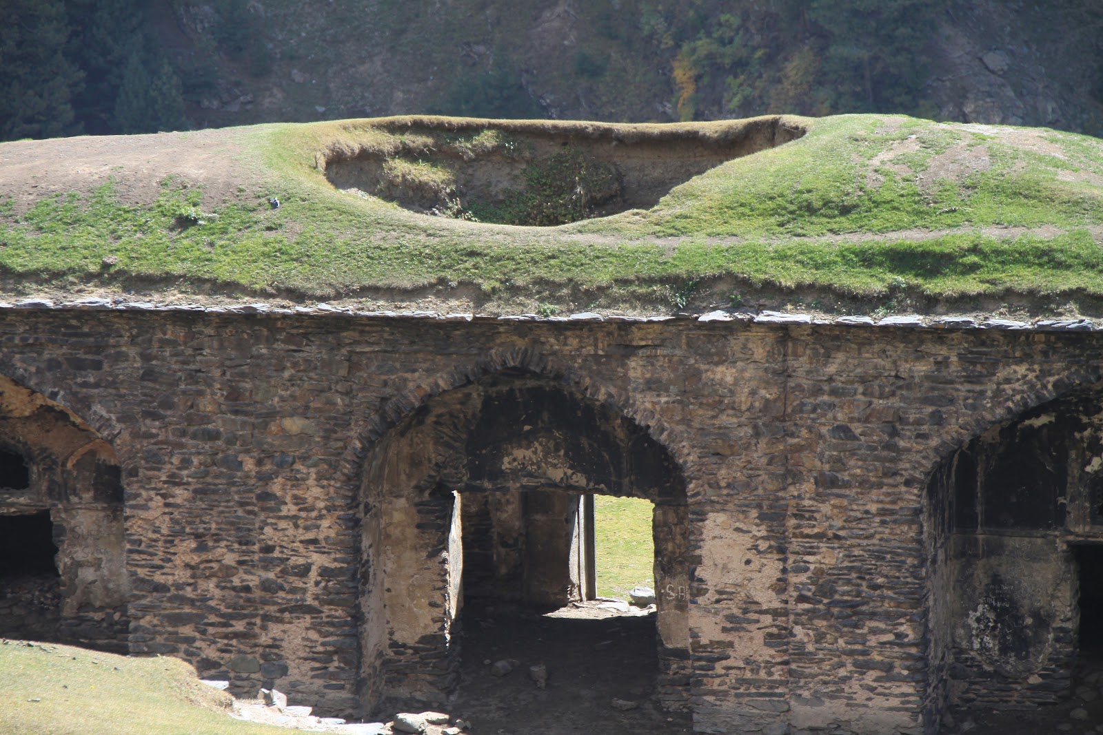
To reach it one has to go steep downhill over a rock fall followed by a pleasant downhill walk over the enveloping meadow. The Serai is about 50 X 40 mtrs and its gate is an imposing 7 mtrs high. The dome above the gate has caved in but the roof on the rest of the spacious complex is still there. There is meaningless and ghastly graffiti all over. The stone door sill is glazed like shining glass by centuries of use. Inside there are rooms behind arched doorways to north, east and west. The royal apartments are in the north heralded by a 4 mtr high arched darwaza. Ever since the Mughals stopped coming here the most regular occupants have been the Gujars. The Gujars have removed stones to have direct access to some rooms from outside. Smell of their flocks is everywhere and the walls are black from numberless fires. Some stones and wooden beams have been removed, and the lattice windows in the royal apartments broken. The mortar from the stone walls is also coming out. In winter the Serai is so full of with snow that entry is impossible. A little above the Serai are some graves surrounded by wilting mazar posh, iris lilies that are planted in cemeteries in Kashmir. Earlier people from SW Kashmir would bring the dead to bury them here, as close as possible to the Ziarat on Pir Gali. Above the Serai is a Gujar doka- a flat thick mud roofed hut. This is the traditional style that houses in Rajouri and Punch were made before prosperity made them switch to concrete. The vast green Pir Marg (meadow)in mid October was liberally sprinkled with yellow anemoines and potentillas. In July and August the carpet of flowers is much thicker and varied.
& more of its decapitated magnificence-


'A Gujar Dhoka that has been built with stones removed from Aliabad Serai...'

The Jammu & Kashmir Government has not done anything to protect and preserve this pearl from history. It’s a tribute to the engineering skills of the Mughals that this structure still stands despite consistent depredation through the ages. High above the serai and a little below the road is a sulphur spring, which attracts most of the Kashmiris driving by, as it has medical properties. Few tourists go on this road as there are no facilities at Rajouri or along the way.
The road to the Pir Panjal Pass rises slowly hugging gentle contours of alps. There is not a single hairpin bend, making it easy for even the driver to revel in the pretty views. There are a few distressing signs of environmental damage, some of which could have been avoided.

The historic Pir Panjal or Pir Gali (3494 m), as it is called now, is a wide V shaped pass at the end of a long meadow, strewn with rock falls in places. Bereft of snow it is not an impressive pass, and with the motor road, police and army huts and tents, the ubiquitous check post without which the security forces do not feel secure, a helipad and wireless antennae, its glory is considerably dimmed.


There is a ziarat built atop a fakir’s grave here. During Jehangir’s time a fakir, Sant Baba Sheikh Karim, famous for asking his procession not to make too much noise, used to meditate here and after his death was buried here. This fakir used to offer visitors water from the sulphur spring outside Aliabad serai. Late 19th C accounts (like Guide to Kashmir by Maj. Arthur Neve, 1892) say that from the ziarat Rawalpindi and Lahore could be seen on some clear days, but one cannot see even half that far now because of a perpetual haze.
The drama comes when the pass is crossed. The view is dramatic and disgusting.

Elephants on the Mughal Road: The Mughal emperors used elephants to visit the Valley. On a steep section like this one elephant, in Jehangir's mammoth caravan, slipped and brought down several others. Many humans and elephants were killed.


Majestic deodars standing ram road straight about 30 to 40 mtrs high had delighted trekkers till the early 80s. These dense forests of Poshiana, Dargiana, Chattapani and Chandimarh had fascinated Mughal and Kashmiri poets, British explorers and hunters and Indian trekkers. Thousands of these trees have been slaughtered. The ground has literally been pulled away from under their roots. Some dead trees teeter drunkenly or are splayed helplessly by road sides or on hill sides, their grandeur stripped, waiting to be carted away to saw mills. In a few places can be seen old meadows, defying gravity, that are about to disappear as the ground beneath them has been cut away. The damage has been done and only reforestation can restore some of their lost eminence. In about 30 years new firs will be one third their full height. But that will not be in our life time.
After Chattapani stream, which is in the middle of a long U bend, the road slices a long impressive waterfall before Chandimarh that in better times used to roar through a thick and dark forest and emerge on to a high rock bursting into gossamer thin sprays and fountains. This sight had inspired an enchanted Nur Jehan to build a pavilion opposite it to admire it at leisure. There seems to be no sign of this structure as the old trekking paths had by passed it and the road has gone above it. Maybe it could be found and restored. Maybe even the forest too could be refreshed.

'Noor-e-Chamb- a pavillion that Nur jehan had had built for her bath is somewhere here but the road builders could not say where. Hope it exists.'
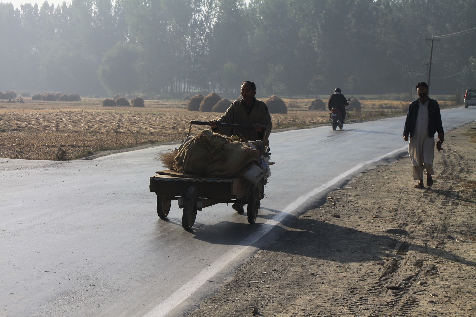
In October many Gujar caravans block the road on their way down, just as in May they do so while on their way up to the higher pastures. The Gujars families with their thousands of goats and sheep and attendant horses and dogs have benefited the most from this road, on which they have the right of way and cause frequent jams.


From Dogrian the road is comfortably tarred. Near Behramgalla the Chattapani meets with Parnai river to form the Surna, which is crossed at Bafliaz. The new road joins a 40 year old one here. Bafliaz (1300 m) is a large prosperous and busy village with roads to Punch and Rajouri bifurcating from here. The higher one goes to Rajouri through a closely planted young forest of firs, few elms and oaks. The earlier forest had been destroyed at the time of building the road about 40 years ago. This forest is already so thick that there are very few gaps to see the Pir Panjal Range and especially the Tata Kutti (4752 m) and Sunset peaks (4745 m).


Change is also seen in electricity pylons, mobile towers, dish TVs, many way side shops, schools, veterinary hospitals and dispensaries. There are a few surviving traditional flat thick mud roofed houses clinging to steep hill sides. The rest are concrete and tin roofed. From Bafliaz a thickly forest shaded section starts. Its a new (about 25 years old) forest. Seeing this man made forest I think that there could be hope for the denudation left behind. But in those years need for quick bucks was a bit less.


At the edge of the 22 kms long forest road that goes over a pass called Dera Ki Gali (2710 m) denuded hill sides start at the village of Azmatabad (Manial). Then comes the pretty urbanized cluster of Thana Mandi above the crystal clear Mangora or Thana nadi. In the heart of this entirely concrete town is an old Mughal serai, and fortunately for its future the Army has occupied it, thereby protecting it.
Thana Mandi's Mughal Serai- saved by Army's occupation>

Kashmir Government is indifferent to its priceless heritage as well as to its glorious environment. A ruin of a Mughal wall is all that remains of the Serai at Saaj>

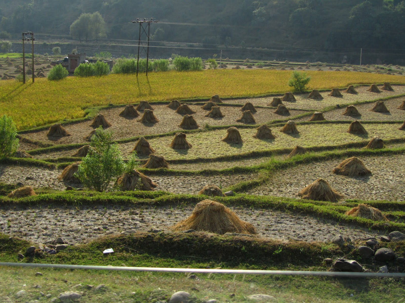
In mid September the ripe yellow paddy fields and rain washed sweeping green hill sides and in early October the geometrically arranged hay stacks of cut paddy are a delight to look at.

An open air school bathed in warm sunlight belwo Dera ki Gali>


'A rare sight outside the Kashmir Valley: A large Chinar near Saaj at a height of about 900 mtrs asl'
All along the way were Mughal serais but they have gone, their stones taken away. In Saaj only a small part of an arch is left. Thus is history ignored and reviled by the J & K Government’s Department of Archaeology.
As one comes near the low hills encircled Rajouri- a border town- the road is broken and rough and its sides have garbage stretching deep into the alleys that lead to it, an ugly contrast to its leafy and hilly surroundings. The Thana nadi meets the Dharwali Tao river at the entrance to Rajouri and their clean waters are sullied by plastic bags and filth. Congested, insanitary and neglected Rajouri (1022 m) is best observed from atop the Dhandhari fort made by Maharaja Gulab Singh in 1846 to keep his Dogra troops and store the grain that was forcibly collected as revenue from the peasants here. Its sole green lung that was a vast park in the heart of the town is now behind walls converted into an army air strip. The neat and extensive cantonment shows that cleanliness is easy, but the civilian authorities will not learn.

'Dirty filthy Rajouri does not look too bad from atop the Dogra Fort Hill.'

'The last ridge is with Pakistan'


'As this fort is an Army OP no pictures allowed inside. But the same view can be had from outside where there are no restrictions.'

'Inside the fort is a problem. Rabbits. Some kind soul sheltered a couple and now their numbers increase daily'
Now that Rajouri and South Kashmir are only 5 hours apart, apples and love cross the Pir Panjal pass to bring cheer to both sides. B grade apples that were earlier sold in Rajouri and Punch for Rs 100 a kg can now be bought for Rs. 30 or so. Same is with walnut and almonds. And some of the Kashmiri men who bring these fruits to Rajouri are also marrying girls from the latter region.
There is one more tryst to be kept. 24 kms from here above the right bank of the Nowshera Tawi is Chingus on the road to Jammu. Chingus means intestines in Persian. It was here that Jehangir had died on the 8th of November, 1927. Nur Jehan fearing a bloody war of succession had his entrails removed and buried here. She then had him stitched up and put on an elephant to make it look as if he was alive and left for Lahore, where Jehangir is buried in a mausoleum at Shahdara. His third son Shahjehan succeeded him. His grave is next to a mosque inside a walled serai that came up subsequently. Typically, there is no sign to guide a visitor to this historic site, which is by a busy state highway and often ignored. Only if one is looking for it can it be reached.


Kashmir is exceedingly beautiful, but if nature is to be mistreated its charm and magnificence will be whittled away till several generations later hazy memories will be thought to be mythical. Roads are essential but not greed.
2 comments:
More people need to read this blog if we want to leave something worthwhile for the next generations. And more people need to read this blog so that they can stop and think of where they are rushing in the name of progress and to think of things beyond their noses, things that matter more than living in a rat race.
Great blog you have heree
Post a Comment